
Visit Raleigh · Wake County, North Carolina

A whole county.
One shared map.

Visit Raleigh brings parks, trails, and nearby places together—helping residents and visitors discover more of Wake County.

With Triangle Trails Initiative, Wake County, and municipal partners.
One destination · Many contributorsWake County, North Carolina
564 trail features · 3,085 mapped places.
Map © Mapbox · © OpenStreetMap
Visit Raleigh × Wander01 / 05

Start with the places people love.

The full mapped trail network brings local loops, greenways, and regional connections into one view.

0:00 / 0:28

A sample outing along Walnut Creek Trail and the Centennial Bikeway connection. Access includes connector paths and sidewalk sections. Trail connections · Lake Raleigh · Coffee at the market · Current trail alerts

In Vimal’s words
“We want to enhance the quality of life for the residents, but also create more experiences for the visitors”
Vimal VyasVice President of Data, Security and AI Innovation · Visit RaleighPublished interview · Wake Living, March 2, 2026

The customer story

A connected destination starts
with the people who know it.

How Visit Raleigh, Triangle Trails Initiative, Wake County, and municipal partners brought outdoor places and local hospitality into one shared experience.

Destination
Wake County, North Carolina
Public launch
October 20, 2025
Shared ambition
Quality of place
Built for
Residents and visitors
01 / The shared ambition

Make the region easier to experience.

A family deciding where to go on a Saturday sees possibilities: a greenway, a playground, somewhere to eat afterward. Behind that day out are different organizations, each responsible for a piece of the experience. Parks departments know their trails. Municipal teams know their communities. Visit Raleigh knows the restaurants, attractions, and hospitality businesses that give the region its character.

Bringing those perspectives together was central to the Wander Wake County initiative. For Visit Raleigh, the work connects directly to the Quality of Place priority in its Destination Strategic Plan. Vimal Vyas described that connection in his briefing on the initiative: helping people discover the county’s outdoor assets supports the experience of living here as well as visiting. [1]

The partners had a substantial landscape to share. Visit Raleigh’s launch announcement described more than 300 miles of greenways and trails across Wake County. The opportunity was to help someone see how a familiar park, a trail connection, and an unfamiliar local business could fit together. Wander gave the partnership a common place to present that picture. [2]

02 / The partnership

One shared experience.
Local ownership underneath.

A regional map needs people who can keep it useful. The partnership’s model gives municipal teams a role in maintaining the information they know best, while Visit Raleigh contributes the hospitality context around those outdoor places.

“An important aspect of this initiative is shared ownership and stewardship. Each municipality owns and maintains their own data within the platform.”

Vimal VyasWander Wake County Initiative briefing · March 5, 2026 [1]

In that briefing, Vimal explained that partners can update greenways and trails, add points of interest, and draw new trails through the platform’s management tools. It is a practical way to keep local knowledge involved as the destination changes. Responsibility for the information stays close to the people who manage the places.

The launch partners contributing and updating trail information included Wake County, Cary, Zebulon, Wake Forest, Apex, and Garner, alongside Visit Raleigh and Triangle Trails Initiative. Vimal also distinguished active contributors from geographic coverage: the map includes communities throughout Wake County using available open data. A place appearing on the map does not mean every municipality has the same contribution role. [1]

For a person exploring, those organizational differences can recede into the background. They can look across the region in one experience while the partnership maintains the local responsibilities that make the information meaningful.

03 / Trails connect the day

Show what the trail makes possible.

The relationship between trails and nearby places is central to this story. A trail line becomes more useful when someone can also see where it leads, what they could stop to explore, and how outdoor time might connect with food or another activity.

The animation above follows a researched example in Raleigh: Lake Johnson, Lake Raleigh, and the State Farmers Market. The City of Raleigh documents these connections along Walnut Creek Trail and the Centennial Bikeway Connector. Parts of the connection use sidewalks and other access paths, so the sequence presents an idea for exploring rather than a turn-by-turn itinerary. [3]

  1. 01

    Begin at Lake Johnson.

    The waterfront and park provide a starting point. Keeping Walnut Creek Trail visible reveals how this place sits within a larger network.

  2. 02

    Discover Lake Raleigh.

    NC State’s Centennial Campus offers another publicly accessible lakeside destination. Its greenway connections place the lake within the same landscape of possibilities. [4]

  3. 03

    Connect with local food.

    The State Farmers Market adds produce, regional food, and places to eat. Its 321 Coffee location offers another reason to explore beyond the water. [5]

  4. 04

    Discover a nearby landmark.

    Near the northern end of the blue Centennial Bikeway Connector, Holy Name of Jesus Cathedral adds another place to discover. The cathedral is also listed by Visit Raleigh. Cathedral details

These real places become easier to understand in relation to the trail network. Seeing them together helps explain the destination’s value in everyday terms: an outdoor activity can open up several ways to spend the rest of the day.

Planning a visit? Check current trail alerts, access details, and individual business hours before setting out.

04 / Vimal’s everyday example

Dinner can be the beginning
of the evening.

Vimal’s own example brings the idea closer to home. In an August email with the subject True connectivity, he described a family having dinner at the Mayton Inn and discovering a movie that evening at Downtown Cary Park. His enthusiasm centered on the options a family could see while already out enjoying the destination. [6]

“it provides families the ability to see many options.”

Vimal VyasExcerpt from “True connectivity” · August 15, 2026 [6]

That is a useful test for a destination experience. Can someone discover something nearby at the moment they are deciding what to do next? The connection might be between a trail and a coffee shop, or between dinner and an event. In both cases, the value comes from seeing the possibilities in relation to where the person already is.

Vimal had made a similar point in his initiative briefing, describing the search for restaurants, ice cream, coffee, bakeries, or breweries around a park visit with family and friends. Combining that hospitality information with outdoor places gives the map a role throughout an outing. [1]

05 / Out in the community

A shared map meets
a real place.

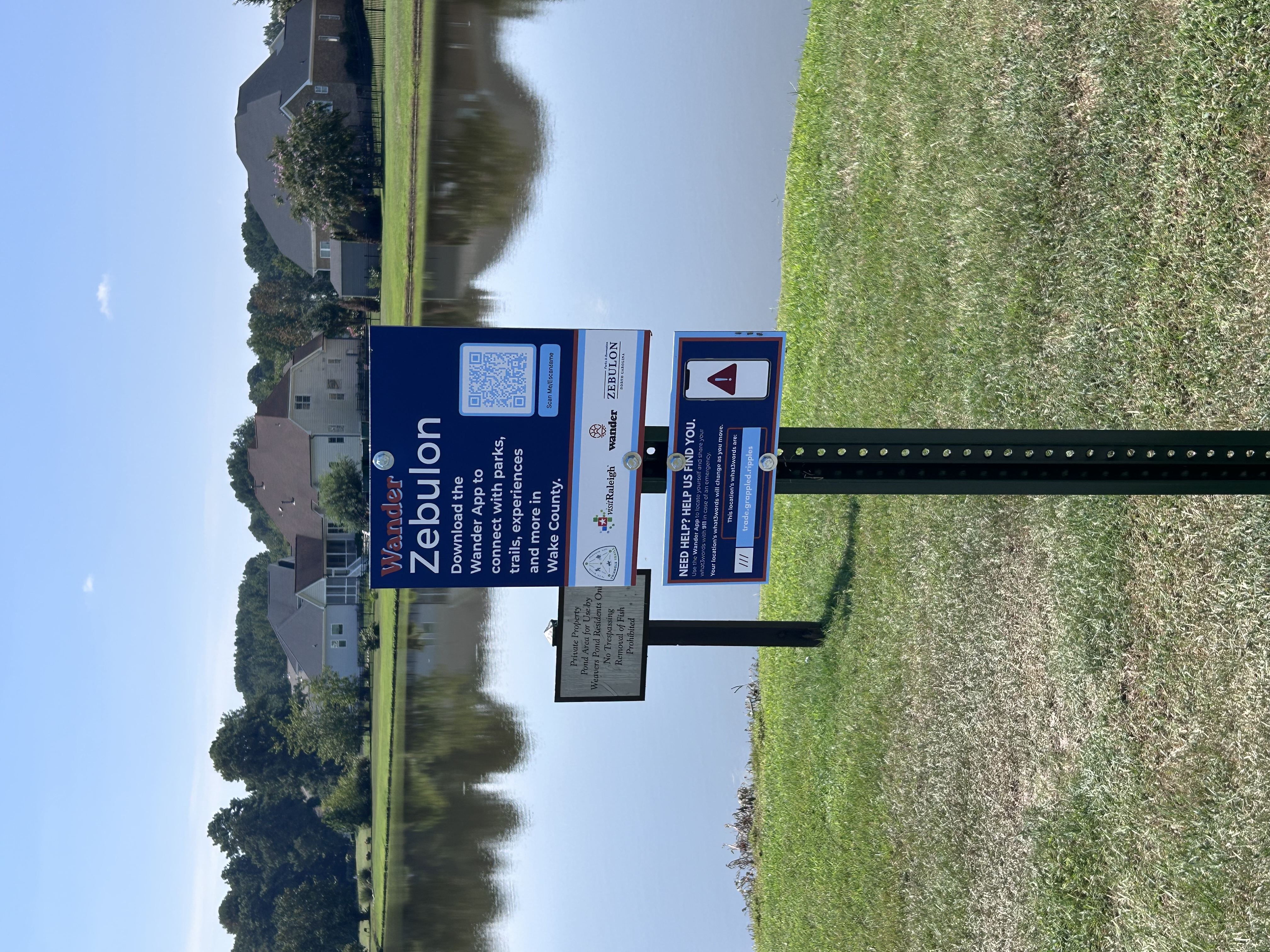
The Zebulon installations pictured below make the partnership visible on the ground. Each sign invites people to download Wander to connect with parks, trails, and experiences across Wake County. The QR code gives someone who encounters the sign a way to take that next step.

The partner logos tell another part of the story. Triangle Trails Initiative, Visit Raleigh, Wander, and Zebulon appear together on a local installation. The regional collaboration becomes something a person can encounter beside a path, in the middle of an ordinary day.
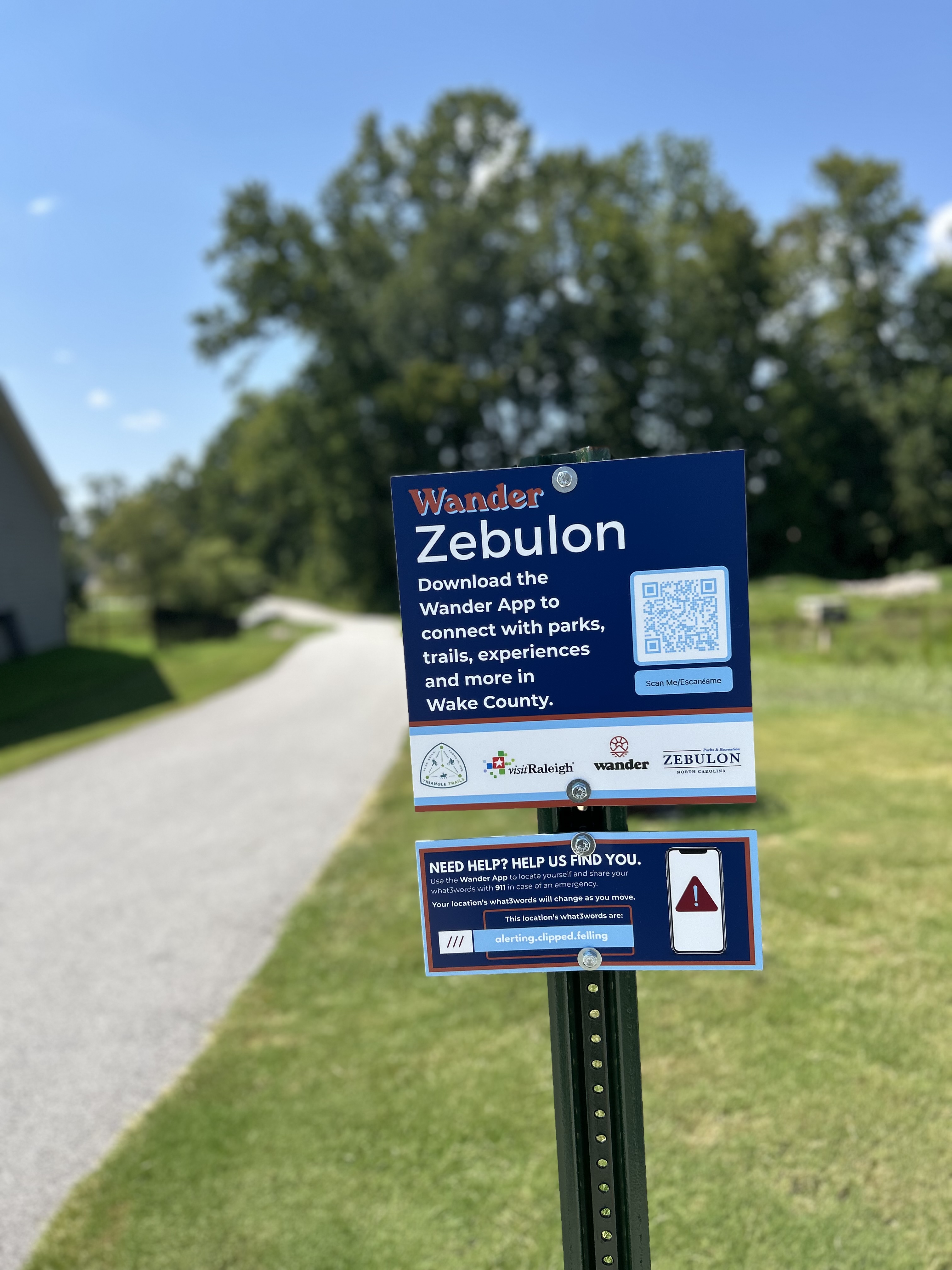
An installed blue Wander Zebulon sign beside a paved path, displaying a QR code and the partner logos.
Wander signage beside a paved path in Zebulon. Photograph courtesy of Wander.
An installed Wander Zebulon sign beside a neighborhood pond, with a separate notice identifying the pond as private property.
A second Zebulon installation beside a neighborhood pond. The pond’s posted access is limited to residents. Photograph courtesy of Wander.

The same approach can meet people online. The initiative includes a free mobile app and a web map that municipalities can embed on their own websites. Vimal pointed to Wake Forest’s parks and recreation website as an example. Someone looking up a park before leaving home and someone discovering Wander beside a trail can enter through different places and explore the same destination. [1]

06 / The work behind the experience

Local knowledge needs
ongoing care.

Shared stewardship also shows up in the less visible work of preparing and maintaining content. Before the public launch, Vimal sent Wander photography from Visit Raleigh’s parks and trails work, together with a list of park records whose images had been updated. He asked for those changes to be reflected in Wander. [7]

That September 2025 exchange gives a concrete example of the operating relationship. Visit Raleigh was contributing destination content and identifying the places it belonged. Wander was being asked to carry those updates into the experience people would use. The collaboration continued at the level of individual parks and photographs.

Vimal’s later briefing described another contribution: curated Visit Raleigh guides that help people discover places through a theme, such as a fall hike or free attractions. Trails, place details, photography, and editorial recommendations each help someone make a decision. Keeping those pieces connected is ongoing destination work. [1]

07 / The road ahead

An experience that can
keep growing with the community.

Vimal’s May 2026 interview notes described his ambition for the next stage of the experience:

“a shift from a static guide experience to something much more interactive, social, and community-driven”

Vimal VyasExcerpt from proposed interview notes · May 18, 2026 [8]

Those notes looked ahead to ways people could participate more actively, including challenges, tours, and sharing experiences. They described an evolving direction, with features at different stages of development. The ambition was to give the community more reasons to return and contribute to discovery.

Across his briefing, content updates, and everyday examples, Vimal returns to a consistent idea: the value grows when people can see connections. Between municipal trail networks. Between outdoor recreation and local hospitality. Between the place someone already knows and the next experience they might enjoy.

For destination teams, the Wake County story shows how that idea can become a shared practice. Let local partners contribute what they know. Give those contributions a common home. Make the connections visible, and meet people where they are exploring.

A closer look · Discovery in motion

The places on the map.
The stories taking shape around them.

Vimal’s vision is about helping people see what they could do next. Location observations and anonymous journeys offer another way to understand how people explore the region.

44,082

location data points
in the Raleigh-area GPS study

December 27, 2023 – September 23, 2026

These are recorded observations, not a count of people or trips. The study covers Wander activity across a broader region around Wake County.

Wake County + surrounding areaAggregated location activity · county boundary shown
Area detail from the wider study. Activity is grouped into roughly 3 km cells; each shown cell includes at least five devices. The reveal illustrates the distribution, not the order of travel.

One anonymous journey

Dinner, planned a day ahead.

A person planned Brodeto on Visit Raleigh’s map. The next evening, their phone was there—and they marked the place visited.

© Mapbox © OpenStreetMap

The arc connects a generalized starting region with the place; it is not a recorded route. The avatar is an illustration. No meal purchase or length of stay is inferred.

A greenway for tomorrow

An evening plan. A morning outdoors.

Explore → Plan → On the greenway

In the study, one person explored Apex-area parks and trails in the evening and selected “add to trip” for Beaver Creek Greenway. The next morning, their phone reported a location on the greenway.

It is a small, everyday example of a map helping connect an idea with a place someone later reaches.

A trail in another town

Discover something farther across the county.

Browse trails → Find a place → Visit later

Another person browsed trails and opened Beaverdam Creek Greenway in Zebulon. About two weeks later, the study recorded their phone at that greenway, with repeated observations on site.

The destination’s value extends beyond familiar places: the shared map can help people discover a different part of the region.

These are selected, anonymous observations. They show map activity followed by presence at a place; they do not establish that a campaign caused a visit. The Brodeto story comes from a separate September 30, 2026 journey review; the greenway stories come from the September 23 regional study.

How to read the location evidence

The 44,082 count removes repeated device, timestamp, latitude, and longitude combinations from the regional study export. The source query accepts GPS records and legacy records without a specified location source; where accuracy is recorded, it must be within 100 meters. Observations are available only when Wander reports location.

The public activity view aggregates observations into cells and omits cells with fewer than five devices. It contains no device identifiers, individual tracks, or exact starting locations. Dates, times, and distances in the stories are generalized. Selected observations cannot establish continuous travel, spending, or campaign attribution.

Source: Wander’s Raleigh/Wake County location study, September 23, 2026; de-identified journey review, September 30, 2026. More about Wander’s journey stories.

Sources & further reading
  1. Vimal Vyas, “Wander Wake County Initiative,” March 5, 2026. Firsthand briefing supplied by email; quotation reproduced as written.
  2. Visit Raleigh’s public launch announcement, October 20, 2025. Trail mileage describes the destination’s assets.
  3. City of Raleigh: Walnut Creek Greenway Trail. Trail connections and sidewalk segments.
  4. NC State: Lake Raleigh. Public access and greenway context.
  5. State Farmers Market and 321 Coffee locations.
  6. Vimal Vyas, “True connectivity,” August 15, 2026. The dinner-and-movie example comes from this email; the excerpt retains its original wording and capitalization.
  7. Vimal Vyas, “Image updates to parks and trails,” September 24, 2025. The two Zebulon installation photographs on this page were supplied by Wander in October 2026.
  8. Vimal Vyas, proposed Wake Living interview notes, May 18, 2026. Used here as a statement of direction, not confirmation of feature availability.
  9. Wake Living: “Find Your Next Favorite Trail With Wander,” March 2, 2026. Source of the opening quotation.

Bring your places and partners
into the same destination story.

Explore Wander for destinations