

Journey 01, Destination Gettysburg
The Return-Trip Planner
A trip back, planned in the middle of the night.
AnonymousPlanned here · around 2 amTippecanoe County, Indiana
Planned: Around 2 am in Tippecanoe County, Indiana, someone opened Destination Gettysburg’s official map in the Wander app. They marked the places they had already been, and picked out Dirty Billy’s Hats, a hat shop just off Lincoln Square, for the trip back.
- The Return-Trip PlannerDestination Gettysburg
Traveled: About 810 km east, two weeks later.
About two weeks later
- The Return-Trip PlannerDestination Gettysburg
Dirty Billy’s HatsShopping · on Destination Gettysburg’s official map
Visited · two weeks later, early in the afternoon
Visited: Two weeks later, early in the afternoon, their phone was at the hat shop.
Anonymous: one phone, shown as a region, with rounded distances and times.
Destination stories
They planned it on the official map. Then they went.
Real trips that started on a destination’s official Wander map: someone taps a place, and later their phone is there. Each journey is one phone, told anonymously, with the time and distance rounded.
Meet the travelers
- The Return-Trip PlannerDestination Gettysburg
 The I-70 Trail ChaserVisit Glenwood Springs
 The Night-Before PlannerYosemite Mariposa County
 The Next-Night Dinner PlanVisit Raleigh
 The Early-Morning Waterfall PickYosemite Mariposa County
 The Morning Chocolate RunDestination Gettysburg
Illustrations, not the travelers. Every journey is anonymous.
Journeys
From a tap on the map to the place itself.
Real trips by real travelers, each one phone, each starting with a tap on a destination’s official Wander map. Scroll to follow them from where they were planned to where they ended up.
Illustrations, not the travelers. Every journey is anonymous.
Every journey is anonymous: the start is shown only as a county or region, drawn from its centre; distances and times are rounded, and days are told relative to the plan. No names, dates or device ids.
Journey 02, Visit Glenwood Springs
The I-70 Trail Chaser
A trailhead, chosen early one afternoon. There three hours later.
AnonymousPlanned here · around 1 pmSummit County, Colorado
Planned: Early one afternoon in Summit County, Colorado, someone opened Visit Glenwood Springs’ official map and tapped the Doc Holliday Trailhead.
- The I-70 Trail ChaserVisit Glenwood Springs
Traveled: About 100 km on to Glenwood Springs, the same afternoon.
About 3 hours later
- The I-70 Trail ChaserVisit Glenwood Springs
Doc Holliday TrailheadMemorials · on Visit Glenwood Springs’ official map
Visited · the same afternoon, around 4 pm
Visited: About three hours later their phone was at the trailhead.
Anonymous: one phone, shown as a region, with rounded distances and times.
Journey 03, Yosemite Mariposa County
The Night-Before Planner
Tomorrow, planned the night before.
AnonymousPlanned here · around 11 pmMariposa County, California
Planned: That evening, someone shared Yosemite Mariposa County’s official map with them. Late that night, in Mariposa County, they planned the next day on it, including a coffee stop in Curry Village.
- The Night-Before PlannerYosemite Mariposa County
Traveled: About 25 km up into the Valley, the next day.
About 14 hours later
- The Night-Before PlannerYosemite Mariposa County
Curry Village Coffee CornerFood and Drink · on Yosemite Mariposa County’s official map
Visited · the next day, around 1 pmStayed about 5 minutes
Visited: By lunchtime the next day their phone was at the Curry Village Coffee Corner, the stop they had opened the night before.
Anonymous: one phone, shown as a region, with rounded distances and times.
Journey 04, Visit Raleigh
The Next-Night Dinner Plan
Dinner, planned a day ahead. There the next evening.
AnonymousPlanned here · around 6 pmChatham County, North Carolina
Planned: Around 6 pm in Chatham County, North Carolina, someone opened Visit Raleigh’s official map in the Wander app and planned dinner at Brodeto.
- The Next-Night Dinner PlanVisit Raleigh
Traveled: About 40 km into Raleigh, the next evening.
About a day later
- The Next-Night Dinner PlanVisit Raleigh
BrodetoFood & Drink · on Visit Raleigh’s official map
Visited · the next evening, around 8 pm
Visited: The next evening, around 8 pm, their phone was at Brodeto, and about a minute later they marked it visited on the map.
Anonymous: one phone, shown as a region, with rounded distances and times.
Journey 05, Yosemite Mariposa County
The Early-Morning Waterfall Pick
A waterfall trail, chosen early one morning.
AnonymousPlanned here · around 7 amMariposa County, California
Planned: Early one morning in Mariposa County, someone opened Yosemite Mariposa County’s official map and tapped the Upper Yosemite Falls Trail.
- The Early-Morning Waterfall PickYosemite Mariposa County
Traveled: About 20 km into the Valley, the same morning.
A few hours later
- The Early-Morning Waterfall PickYosemite Mariposa County
Upper Yosemite Falls TrailHiking · on Yosemite Mariposa County’s official map
Visited · the same morning, around 10 am
Visited: A few hours later their phone was on the trail, just above the trailhead.
Anonymous: one phone, shown as a region, with rounded distances and times.
Journey 06, Destination Gettysburg
The Morning Chocolate Run
A chocolate shop, chosen late one night.
AnonymousPlanned here · around 11 pmCentral Pennsylvania
Planned: Late one night in central Pennsylvania, someone opened Destination Gettysburg’s official map and tapped the Gettysburg Chocolate Market.
- The Morning Chocolate RunDestination Gettysburg
Traveled: About 140 km south, to Gettysburg.
Overnight
- The Morning Chocolate RunDestination Gettysburg
Gettysburg Chocolate MarketCookie · on Destination Gettysburg’s official map
Visited · the next morning, around 10 amStayed about 5 minutes
Visited: The next morning, around 10 am, their phone was at the shop, and it stayed about five minutes.
Anonymous: one phone, shown as a region, with rounded distances and times.
Case studies
Where the official map lives.
What each destination built, where it sits on their own website, and the journeys that started on it. Then fly there and see the map for yourself.
The Next-Night Dinner Plan, on Visit Raleigh’s map© Mapbox © OpenStreetMap Wake County, North Carolina
Visit Raleigh
Connected a whole county’s trails, parks, and local hospitality through one shared map. Read Vimal’s perspective and see discovery in motion.
- Where the map lives
- Embedded on visitraleigh.com as the full map. See it on their site (opens visitraleigh.com in a new tab)
- Journeys that started on it
The Night-Before Planner, on Yosemite Mariposa County’s map© Mapbox © OpenStreetMap Mariposa County, California
Yosemite Mariposa County
Put its official map on yosemite.com, and in people’s pockets for when the signal drops.
- Where the map lives
- Embedded on yosemite.com, on pages such as the Half Dome hike. See it on their site (opens yosemite.com in a new tab)
- Journeys that started on it
The Morning Chocolate Run, on Destination Gettysburg’s map© Mapbox © OpenStreetMap Gettysburg, Pennsylvania
Destination Gettysburg
Put its official map on its own home page, with local businesses on the same map as the battlefield.
- Where the map lives
- Embedded on destinationgettysburg.com as the full map. See it on their site (opens destinationgettysburg.com in a new tab)
- Journeys that started on it
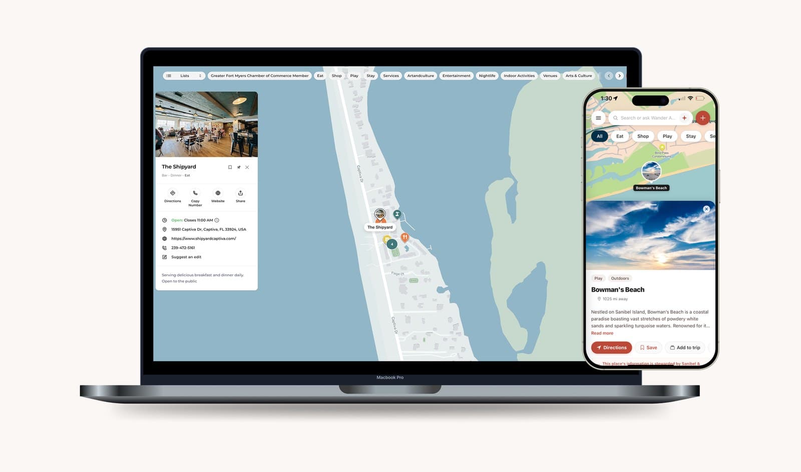
Sanibel and Captiva, Florida
Sanibel & Captiva
Published the islands’ official map for the phone in a visitor’s hand, beaches and local restaurants together.
- Where the map lives
- In the Wander app and on the web.
“Wander is the most valuable tool in our toolbox.”
John Lai, Sanibel & Captiva Chamber of Commerce
Method
About these journeys
Every journey here is one phone on a destination’s official Wander map, and every one is anonymous.
Anonymous, one phone each.
Each journey follows a single phone on a destination’s official map. The names say what the traveler did, and the faces are illustrations: no one here is identified.
A region, not an address.
Where the plan was made is shown as a county or a wider region, drawn from its centre, never the spot where someone tapped.
Rounded distances and times.
Distances are rounded, times of day to the hour, stays to five minutes, and days are told relative to the plan. No dates, weekdays or device ids.
Verified against five checks.
The distance is real; the phone was within 100 m of the place on a fresh location reading, and not where the traveler was staying; the plan’s location matched a fresh reading; the phone showed no Wander or destination staff activity; and the plan was made inside the region named.
Where the phone was, nothing more.
We say a phone was at a shop or on a trail. We never say what someone bought, ate or hiked.
Attribution studies are a service our team runs for a destination: we match anonymous taps on your map to later visits on the ground. A study only sees phones sharing their location, so what it finds is a floor. Results vary by destination, and we never promise a number.
Destinations across the country run their official map on Wander














Your destination’s story could be next.
We’ll build your official map with you, put it where your visitors plan, and show you where it takes them.
See every destination on the globe